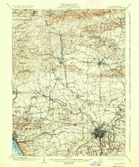
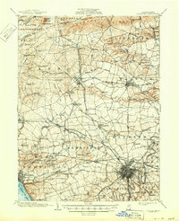
1904 Map of Lancaster
USGS Topo · Published 1936About this map
Manheim and Lititz anchor a landscape defined by an intricate network of turnpikes and railroads at the dawn of the twentieth century. The Pennsylvania R.R. and Philadelphia and Reading R.R. intersect at strategic points like Lancaster Junction, supporting a regional economy tied to the agricultural and industrial outputs of the Pennsylvania Dutch country. Grounded in the survey work of J. H. Wheat and W. Carvel Hall, this topographic study reveals the importance of water power and early manufacturing, noting sites such as Govers Mill on Back Run and the Elizabeth Furnace near the northern gaps. To the south, the city of Lancaster is shown with its radial transportation lines, including the Lancaster and Millersville Electric R.R. and the Lancaster and Ephrata Turnpike. This survey offers a precise record of rural life, from the Pleasant View Church to the small-scale settlements of Mastersonville and Neffsville that dotted the limestone valleys before modern expansion.
Find a feature on this map
123 named features on this map. Tap any name to fly to it.
Don’t see what you’re looking for? This feature index may not catch every label — zoom into the map to look around manually.
Map Details
Editions of this 1904 Lancaster Map
10 editions found
Other maps of this area

1891 · Lebanon
USGS Topo · 1:62,500

1892 · Hummelstown
USGS Topo · 1:62,500

1893 · Lebanon
USGS Topo · 1:62,500

1899 · Lebanon
USGS Topo · 1:62,500

1902 · Wernersville
USGS Topo · 1:62,500

1902 · Lancaster
USGS Topo · 1:62,500

1904 · Lancaster
USGS Topo · 1:62,500

1906 · New Holland
USGS Topo · 1:62,500

1908 · Middletown
USGS Topo · 1:62,500

1908 · New Holland
USGS Topo · 1:62,500
Featured Places
- Lancaster, PA
- West Lampeter Township, PA
- Lititz, PA
- Willow Street, West Lampeter Township
- Millersville, PA