
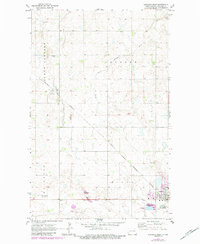
1970 Map of Langdon West
USGS Topo · Published 1972About this map
The South Little Pembina River cuts a winding path through the prairie landscape of northeastern North Dakota, anchoring a region defined by its agricultural townships of South Dresden, Waterloo, and Elgin. The city of Langdon serves as the regional hub at the southeastern edge of the sheet, showing a developed grid that includes the High Sch, Langdon Reservoir, and the Calvary Cem. To the northwest, the smaller settlement of Dresden sits along the Burlington Northern railroad line, which bisects the quadrangle diagonally from northwest to southeast.
Find a feature on this map
20 named features on this map. Tap any name to fly to it.
Don’t see what you’re looking for? This feature index may not catch every label — zoom into the map to look around manually.
Map Details
Editions of this 1970 Langdon West Map
2 editions found
Other maps of this area

1953 · Devils Lake
USGS Topo · 1:250,000

1956 · Devils Lake
USGS Topo · 1:250,000

1967 · Langdon East
USGS Topo · 1:24,000

1967 · Maida
USGS Topo · 1:24,000

1970 · Mount Carmel
USGS Topo · 1:24,000

1970 · Wales
USGS Topo · 1:24,000

1970 · Loma
USGS Topo · 1:24,000

1970 · Hannah SE
USGS Topo · 1:24,000

1972 · Easby
USGS Topo · 1:24,000
1972 · Nekoma NW
USGS Topo · 1:24,000