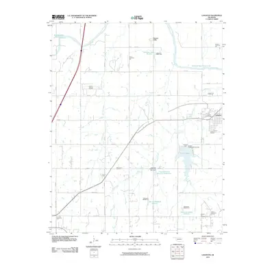
2010 Map of Langston
USGS Topo · Published 2010About this map
Langston University serves as a prominent landmark on this landscape, situated just west of the town of Langston. The area is characterized by the winding path of the Cimarron River in the north and a network of creeks including Antelope Creek and Fitzgerald Creek. These watercourses are managed by numerous small dams and reservoirs, such as Lake Langston and the Oknoname 083007 Reservoir.
Find a feature on this map
51 named features on this map. Tap any name to fly to it.
Don’t see what you’re looking for? This feature index may not catch every label — zoom into the map to look around manually.
Map Details
Editions of this 2010 Langston Map
This is the sole edition of this map. No revisions or reprints were ever made.
Other maps of this area

1892 · Guthrie
USGS Topo · 1:62,500

1893 · Mulhall
USGS Topo · 1:62,500

1893 · Stillwater
USGS Topo · 1:62,500

1909 · Perkins
USGS Topo · 1:62,500

1954 · Oklahoma City
USGS Topo · 1:250,000

1955 · Enid
USGS Topo · 1:250,000

1957 · Oklahoma City
USGS Topo · 1:250,000

1958 · Enid
USGS Topo · 1:250,000

1963 · Oklahoma City
USGS Topo · 1:250,000
1967 · Stillwater SW
USGS Topo · 1:24,000