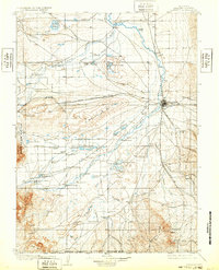
1908 Map of Laramie
USGS Topo · Published 1932About this map
The high plains of Laramie and its surrounding ranchlands are meticulously documented in this early 20th-century survey, conducted shortly after the turn of the century. The Union Pacific River railroad corridor serves as the primary artery for the region, connecting the growing hub of Laramie with smaller stops like Hatton and Millbrook. The landscape is a mix of industrial infrastructure and expansive grazing lands, evidenced by the high concentration of named family properties such as Alsops Ranch, Frazier's Ranch, and Nelson's Road Ranch.
Find a feature on this map
85 named features on this map. Tap any name to fly to it.
Don’t see what you’re looking for? This feature index may not catch every label — zoom into the map to look around manually.
Map Details
Editions of this 1908 Laramie Map
5 editions found
Other maps of this area

1895 · Laramie
USGS Topo · 1:125,000

1902 · Laramie
USGS Topo · 1:125,000

1905 · Sherman
USGS Topo · 1:125,000

1905 · Laramie
USGS Topo · 1:125,000

1906 · Medicine Bow
USGS Topo · 1:125,000

1906 · Laramie
USGS Topo · 1:125,000

1907 · Livermore
USGS Topo · 1:125,000

1908 · Laramie
USGS Topo · 1:125,000

1908 · Medicine Bow
USGS Topo · 1:125,000

1909 · Livermore
USGS Topo · 1:125,000