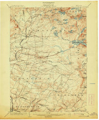
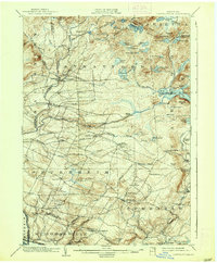
1903 Map of Lassellsville
USGS Topo · Published 1913About this map
Irish Settlement and Glasgow Mills sit amidst a complex network of creeks and small settlements in the southern foothills of the Adirondacks at the turn of the century. The terrain is defined by the heavy descent of Sprite Creek and Caroga Creek toward the Mohawk Valley, powering several mill sites such as Newkirk Mills. To the north, the landscape shifts to a dense concentration of glacial lakes, including Canada Lake, Nine Corner Lake, and the Spectacle Lakes. The southern margin reveals the industrial corridor of the N. Y. C. and H. R. R. R. passing through St. Johnsville. This survey highlights the era of small, localized manufacturing and family-named crossroads like Phipps Cors., Fical Corners, and Shaw Corners, providing a detailed look at the rural social geography of Fulton County before the widespread consolidation of these smaller hamlets.
Find a feature on this map
99 named features on this map. Tap any name to fly to it.
Don’t see what you’re looking for? This feature index may not catch every label — zoom into the map to look around manually.
Map Details
Editions of this 1903 Lassellsville Map
6 editions found

Other maps of this area

1896 · Fonda
USGS Topo · 1:62,500

1898 · Fonda
USGS Topo · 1:62,500

1898 · Canajoharie
USGS Topo · 1:62,500

1900 · Little Falls
USGS Topo · 1:62,500

1900 · Canajoharie
USGS Topo · 1:62,500

1900 · Wilmurt
USGS Topo · 1:62,500

1901 · Lassellsville
USGS Topo · 1:62,500

1902 · Canajoharie
USGS Topo · 1:62,500

1902 · Fonda
USGS Topo · 1:62,500

1902 · Wilmurt
USGS Topo · 1:62,500