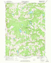
1968 Map of Laurel Lake
USGS Topo · Published 1971About this map
Glacial lakes and small rural settlements dot this section of the Endless Mountains along the New York-Pennsylvania border in the late 1960s. The landscape is defined by its water bodies, from the prominent Quaker Lake and Laurel Lake to smaller reaches like Lake Sophia and Dora Pond. These lakes served as focal points for local development, while the upland areas were punctuated by numerous Quarries, indicating the region's reliance on stone extraction. Small communities such as Brackney and St Joseph provided social anchors, evidenced by the presence of Brackney Cem and St Augustine Church. The map also reveals the rural infrastructure of the era, with early Telephone and Pipeline corridors cutting across townships like Silver Lake and Franklin. The numerous fine red dashed lines provide a detailed record of fence and field lines as they existed during the 1966 aerial photography, offering genealogists a way to trace historic property boundaries and land use patterns.
Find a feature on this map
44 named features on this map. Tap any name to fly to it.
Don’t see what you’re looking for? This feature index may not catch every label — zoom into the map to look around manually.
Map Details
Editions of this 1968 Laurel Lake Map
2 editions found
Other maps of this area

1901 · Apalachin
USGS Topo · 1:62,500

1904 · Binghamton
USGS Topo · 1:62,500

1904 · Apalachin
USGS Topo · 1:62,500

1906 · Catatonk
USGS Topo · 1:125,000

1935 · Binghamton West
USGS Topo · 1:24,000

1937 · Binghamton East
USGS Topo · 1:24,000

1942 · Binghamton West
USGS Topo · 1:31,680

1942 · Binghamton East
USGS Topo · 1:31,680

1943 · Montrose
USGS Topo · 1:62,500

1943 · Le Raysville
USGS Topo · 1:62,500