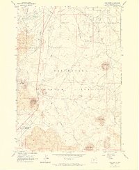
1963 Map of Lava Butte
USGS Topo · Published 1964About this map
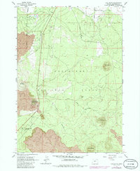
Volcanic landforms and early water management infrastructure dominate this mid-century survey of the Oregon high desert. The prominent cinder cone of Lava Butte, topped by its lookout station, serves as a central landmark overlooking the extensive lava fields that define the local topography. To the south, Lava River Caves State Park preserves the subterranean passages left by cooling basalt. The Great Northern railroad cuts a straight north-south line through this terrain, paralleling the arterial highway as it moves through the Deschutes National Forest.
Find a feature on this map
22 named features on this map. Tap any name to fly to it.
Don’t see what you’re looking for? This feature index may not catch every label — zoom into the map to look around manually.
Map Details
Editions of this 1963 Lava Butte Map
5 editions found
Other maps of this area

1926 · Bend
USGS Topo · 1:125,000

1929 · Bend
USGS Topo · 1:125,000

1931 · Newberry Crater
USGS Topo · 1:125,000

1935 · Newberry Crater
USGS Topo · 1:125,000

1955 · Crescent
USGS Topo · 1:250,000

1955 · Bend
USGS Topo · 1:250,000

1957 · Crescent
USGS Topo · 1:250,000

1957 · Bend
USGS Topo · 1:250,000

1958 · Crescent
USGS Topo · 1:250,000

1958 · Bend
USGS Topo · 1:250,000