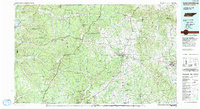
1985 Map of Lawrenceburg
USGS Topo · Published 1991About this map
Lawrenceburg and the surrounding high ridges of south-central Tennessee dominate this mid-1980s topographic survey. The landscape is defined by the sharp contrast between the dense wooded uplands of the Eagle Creek State Wildlife Management Area and the fertile river valleys carved by the Buffalo River and Shoal Creek. Transport across this terrain follows the historic route of the Natchez Trace Parkway, which winds through the western portion of the region, while the L & N RR provides a rail backbone connecting Ethridge and Loretto.
Find a feature on this map
112 named features on this map. Tap any name to fly to it.
Don’t see what you’re looking for? This feature index may not catch every label — zoom into the map to look around manually.
Map Details
Editions of this 1985 Lawrenceburg Map
2 editions found
Other maps of this area

1888 · Huntsville
USGS Topo · 1:125,000

1892 · Huntsville
USGS Topo · 1:125,000

1901 · Colombia
USGS Topo · 1:125,000

1905 · Waynesboro
USGS Topo · 1:125,000

1911 · Iuka
USGS Topo · 1:48,000

1914 · Iuka
USGS Topo · 1:62,500

1914 · Rogersville
USGS Topo · 1:48,000

1914 · Muscle Shoals
USGS Topo · 1:48,000

1916 · Muscle Shoals
USGS Topo · 1:62,500

1916 · Rogersville
USGS Topo · 1:62,500