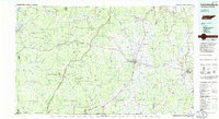
1985 Map of Lawrenceburg
USGS Topo · Published 1985About this map
Lawrenceburg and the surrounding central Tennessee highlands are defined by a complex network of waterways and ridges in the mid-1980s. The landscape transitions from the broad Tennessee River and Kentucky Lake in the west, through the heavily wooded Laurel Hill Wildlife Management Area, to the agricultural and residential centers of Pulaski and Waynesboro. Significant landmarks like David Crockett State Park and the Lawrenceburg Speedway and Dragstrip highlight the region's recreational character during this era.
Find a feature on this map
278 named features on this map. Tap any name to fly to it.
Don’t see what you’re looking for? This feature index may not catch every label — zoom into the map to look around manually.
Map Details
Editions of this 1985 Lawrenceburg Map
2 editions found
Other maps of this area

1888 · Huntsville
USGS Topo · 1:125,000

1892 · Huntsville
USGS Topo · 1:125,000

1901 · Colombia
USGS Topo · 1:125,000

1905 · Waynesboro
USGS Topo · 1:125,000

1911 · Iuka
USGS Topo · 1:48,000

1914 · Iuka
USGS Topo · 1:62,500

1914 · Rogersville
USGS Topo · 1:48,000

1914 · Muscle Shoals
USGS Topo · 1:48,000

1916 · Muscle Shoals
USGS Topo · 1:62,500

1916 · Rogersville
USGS Topo · 1:62,500