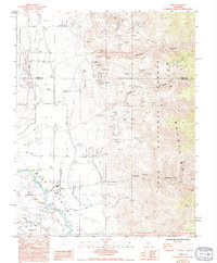
1984 Map of Laws
USGS Topo · Published 1994About this map
The settlement of Laws serves as a focal point in this 1984 survey, situated where the Owens River valley meets the rising slopes of the White Mountains. This area preserves a distinct record of early California transportation and water management, featuring the Railroad Museum and an extensive network of irrigation infrastructure including the Joe Smith Canal Road. The geography is defined by the contrast between the flat Chalfant Valley and the geological complexity of the Volcanic Tableland to the west.
Find a feature on this map
27 named features on this map. Tap any name to fly to it.
Don’t see what you’re looking for? This feature index may not catch every label — zoom into the map to look around manually.
Map Details
Editions of this 1984 Laws Map
2 editions found
Other maps of this area

1913 · Bishop
USGS Topo · 1:125,000

1917 · White Mountain
USGS Topo · 1:125,000

1947 · Mariposa
USGS Topo · 1:250,000

1948 · Mariposa
USGS Topo · 1:250,000

1949 · Bishop
USGS Topo · 1:62,500

1951 · Bishop
USGS Topo · 1:62,500

1951 · Blanco Mountain
USGS Topo · 1:62,500

1957 · Mariposa
USGS Topo · 1:250,000

1962 · Mt. Barcroft
USGS Topo · 1:62,500

1962 · White Mtn. Peak
USGS Topo · 1:62,500