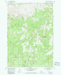
1968 Map of Lawson Mtn
USGS Topo · Published 1985About this map
West Branch Cemetery and the Fitzgerald Ranch serve as key landmarks in this Wheeler County landscape, which transitions from the northern reaches of the Och Oco National Forest into a complex system of volcanic buttes and canyons. The terrain is defined by prominent elevations such as Lawson Mtn, Bailey Butte, and the distinctive Courthouse Rock. Water sources are vital here, with numerous named springs including Heflin Spring and the curiously named Sheep Smother Spring feeding into West Branch Bridge Creek and Carroll Creek. The presence of a Landing Strip and a Borrow Pit alongside the various flats, like Ross Flat and Do Little Flat, illustrates the balance of ranching life and small-scale resource extraction in this part of Oregon during the late 1960s and early 1980s.
Find a feature on this map
45 named features on this map. Tap any name to fly to it.
Don’t see what you’re looking for? This feature index may not catch every label — zoom into the map to look around manually.
Map Details
Editions of this 1968 Lawson Mtn Map
2 editions found
Other maps of this area

1926 · Mitchell
USGS Topo · 1:125,000

1951 · Lookout Mtn
USGS Topo · 1:62,500

1955 · Bend
USGS Topo · 1:250,000

1957 · Bend
USGS Topo · 1:250,000

1958 · Bend
USGS Topo · 1:250,000

1966 · Mt. Pisgah
USGS Topo · 1:24,000

1966 · Mitchell
USGS Topo · 1:62,500

1968 · Painted Hills
USGS Topo · 1:24,000

1968 · Lawson Mtn
USGS Topo · 1:24,000

1968 · Stephenson Mtn
USGS Topo · 1:24,000