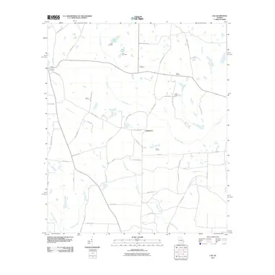
2011 Map of Lax
USGS Topo · Published 2011About this map
The Satilla River meanders through this portion of Coffee County, defining a landscape of agricultural roads and scattered family settlements during the early 21st century. The small community of Lax anchors the northwestern corner, surrounded by a network of rural routes including Old Columbus Rd and Sweet Pea Rd. The map reveals a dense concentration of local family history through its numerous burial sites, including the Joseph Carver Cemetery, Vickers Cemetery, and Luke Cemetery.
Find a feature on this map
57 named features on this map. Tap any name to fly to it.
Don’t see what you’re looking for? This feature index may not catch every label — zoom into the map to look around manually.
Map Details
Editions of this 2011 Lax Map
This is the sole edition of this map. No revisions or reprints were ever made.
Other maps of this area

1953 · Waycross
USGS Topo · 1:250,000

1958 · Waycross
USGS Topo · 1:250,000

1972 · Tenmile Bay
USGS Topo · 1:24,000

1972 · Kirkland
USGS Topo · 1:24,000

1972 · Willacoochee
USGS Topo · 1:24,000

1972 · Lax
USGS Topo · 1:24,000

1972 · Ambrose
USGS Topo · 1:24,000

1972 · Ocilla East
USGS Topo · 1:24,000

1972 · Mora
USGS Topo · 1:24,000
1977 · Mora
USGS Topo · 1:24,000