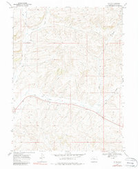
1969 Map of Lay SE
USGS Topo · Published 1987About this map
Lay Creek and the North Fork define this high-plateau landscape in Moffat County, where the topography of the late 1960s is marked by early energy exploration and rural infrastructure. The map reveals a distribution of scattered extractive activities, including multiple Drill Holes, Oil Wells, and a specific Oil Well site south of Big Gulch. These features, alongside the presence of a Flowing Well and Gravel Pits, highlight the area's transition from open range to a more industrialised resource landscape. Road 40 cuts through the southern half of the quadrangle, serving as the primary corridor through this terrain of deep gulches and high ridges. The detailed surveying captures the exact placement of these wells and pits before further expansion of the regional energy sector altered the surface character of the land.
Find a feature on this map
13 named features on this map. Tap any name to fly to it.
Don’t see what you’re looking for? This feature index may not catch every label — zoom into the map to look around manually.
Map Details
Editions of this 1969 Lay SE Map
4 editions found
Other maps of this area

1910 · Danforth Hills
USGS Topo · 1:125,000

1912 · Axial
USGS Topo · 1:62,500

1914 · Axial
USGS Topo · 1:62,500

1915 · Monument Butte
USGS Topo · 1:62,500

1916 · Craig
USGS Topo · 1:125,000

1954 · Craig
USGS Topo · 1:250,000

1957 · Craig
USGS Topo · 1:250,000

1958 · Craig
USGS Topo · 1:250,000

1960 · Craig
USGS Topo · 1:250,000

1962 · Craig
USGS Topo · 1:250,000