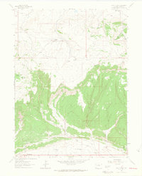
1962 Map of Lazy Y Point
USGS Topo · Published 1965About this map
Lazy Y Summer Camp and Ramsey Summer Camp occupy the high country of Moffat County in the early 1960s, a period when this part of northwestern Colorado remained focused on seasonal ranching and recreation. The landscape is defined by the massive presence of Blue Mountain to the south and Moose Head Mountain in the west, with the drainage of Wolf Creek carving through the northern sections.
Find a feature on this map
24 named features on this map. Tap any name to fly to it.
Don’t see what you’re looking for? This feature index may not catch every label — zoom into the map to look around manually.
Map Details
Editions of this 1962 Lazy Y Point Map
4 editions found
Other maps of this area

1907 · Rangely
USGS Topo · 1:125,000

1910 · Rangely
USGS Topo · 1:125,000

1954 · Hells Canyon
USGS Topo · 1:24,000

1954 · Vernal
USGS Topo · 1:250,000

1958 · Vernal
USGS Topo · 1:250,000

1960 · Vernal
USGS Topo · 1:250,000

1962 · Lazy Y Point
USGS Topo · 1:24,000

1962 · Tanks Peak
USGS Topo · 1:24,000

1962 · Rangely NE
USGS Topo · 1:24,000

1962 · Cactus Reservoir
USGS Topo · 1:24,000