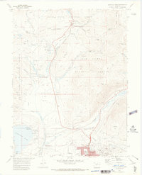
1970 Map of Leadville North
USGS Topo · Published 1973About this map
Matchless Mine and the Hayden Mine anchor the eastern industrial landscape of this high-altitude survey, reflecting the intensive mineral exploration around Fryer Hill. The northern boundary of Leadville is clearly defined, with civic life represented by West Park Sch, City Hall, and the expansive Evergreen Cem. To the west, the reservoir of Turquoise Lake serves as a major recreation hub, featuring the Molly Brown Campground and Baby Doe Campground, names that nod to the area’s storied mining heritage.
Find a feature on this map
69 named features on this map. Tap any name to fly to it.
Don’t see what you’re looking for? This feature index may not catch every label — zoom into the map to look around manually.
Map Details
Editions of this 1970 Leadville North Map
4 editions found
Other maps of this area

1889 · Leadville
USGS Topo · 1:125,000

1891 · Leadville
USGS Topo · 1:125,000

1934 · Climax
USGS Topo · 1:48,000

1935 · Mount Elbert
USGS Topo · 1:62,500

1938 · Mt. Lincoln
USGS Topo · 1:48,000

1938 · Mount Elbert
USGS Topo · 1:62,500

1939 · Mount Elbert
USGS Topo · 1:62,500

1942 · Leadville
USGS Topo · 1:125,000

1945 · Mount Lincoln
USGS Topo · 1:62,500

1949 · Holy Cross
USGS Topo · 1:62,500