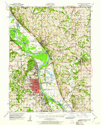
1948 Map of Leavenworth
USGS Topo · Published 1960About this map
Fort Leavenworth Military Reservation and the sprawling correctional facilities of the Federal Penitentiary and Kansas State Penitentiary anchor this 1948 survey of the Missouri River bend. The landscape is defined by the sharp contrast between the dense urban grid of Leavenworth and the floodplains of Weston Bend and Delaware Bend. Regional connectivity in the late 1940s is shown through the Chicago Great Western and Chicago Burlington And Quincy railroads, which serviced river towns like Weston and Platte City.
Find a feature on this map
116 named features on this map. Tap any name to fly to it.
Don’t see what you’re looking for? This feature index may not catch every label — zoom into the map to look around manually.
Map Details
Editions of this 1948 Leavenworth Map
4 editions found

Other maps of this area

1885 · Atchison
USGS Topo · 1:125,000

1886 · Oskaloosa
USGS Topo · 1:125,000

1888 · Oskaloosa
USGS Topo · 1:125,000

1888 · Atchison
USGS Topo · 1:125,000

1890 · Kansas City
USGS Topo · 1:125,000

1893 · Atchison
USGS Topo · 1:125,000

1894 · Kansas City
USGS Topo · 1:125,000

1894 · Oskaloosa
USGS Topo · 1:125,000

1910 · Leavenworth
USGS Topo · 1:62,500

1914 · Smithville
USGS Topo · 1:62,500