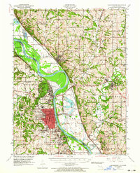
1948 Map of Leavenworth
USGS Topo · Published 1964About this map
The Missouri River carves a winding path through this mid-century landscape, separating the bustling city of Leavenworth, Kansas, from the rural bottomlands of Platte County, Missouri. This map captures a significant concentration of federal and military infrastructure, dominated by the Fort Leavenworth Military Reservation, Sherman Army Airfield, and the Federal Penitentiary. The river’s influence is visible in features like Harpst Island and the oxbow-adjacent Mud Lake, while the transportation network is anchored by the Chicago Burlington and Quincy and Missouri Pacific railroads.
Find a feature on this map
109 named features on this map. Tap any name to fly to it.
Don’t see what you’re looking for? This feature index may not catch every label — zoom into the map to look around manually.
Map Details
Editions of this 1948 Leavenworth Map
4 editions found

Other maps of this area

1885 · Atchison
USGS Topo · 1:125,000

1886 · Oskaloosa
USGS Topo · 1:125,000

1888 · Oskaloosa
USGS Topo · 1:125,000

1888 · Atchison
USGS Topo · 1:125,000

1890 · Kansas City
USGS Topo · 1:125,000

1893 · Atchison
USGS Topo · 1:125,000

1894 · Kansas City
USGS Topo · 1:125,000

1894 · Oskaloosa
USGS Topo · 1:125,000

1910 · Leavenworth
USGS Topo · 1:62,500

1914 · Smithville
USGS Topo · 1:62,500