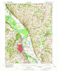
1948 Map of Leavenworth
USGS Topo · Published 1965About this map
Leavenworth and its surrounding military and penal landscape dominate this mid-century survey of the Missouri River valley. The map reveals a dense concentration of institutional land use, including the expansive Fort Leavenworth Military Reservation, Sherman Army Airfield, and both the Federal Penitentiary and Kansas State Penitentiary. Across the river in Missouri, the landscape transitions to a patchwork of rural school districts and family cemeteries, such as Hawkins Cemetery and Fulton Cemetery, illustrating the settlement patterns of the Weston and Platte City vicinities.
Find a feature on this map
104 named features on this map. Tap any name to fly to it.
Don’t see what you’re looking for? This feature index may not catch every label — zoom into the map to look around manually.
Map Details
Editions of this 1948 Leavenworth Map
4 editions found

Other maps of this area

1885 · Atchison
USGS Topo · 1:125,000

1886 · Oskaloosa
USGS Topo · 1:125,000

1888 · Oskaloosa
USGS Topo · 1:125,000

1888 · Atchison
USGS Topo · 1:125,000

1890 · Kansas City
USGS Topo · 1:125,000

1893 · Atchison
USGS Topo · 1:125,000

1894 · Kansas City
USGS Topo · 1:125,000

1894 · Oskaloosa
USGS Topo · 1:125,000

1910 · Leavenworth
USGS Topo · 1:62,500

1914 · Smithville
USGS Topo · 1:62,500