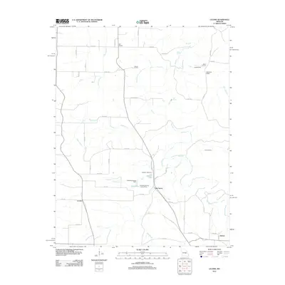
2012 Map of Lecoma
USGS Topo · Published 2012About this map
Lecoma and Lake Spring anchor this portion of Dent County, characterized by a complex network of waterways feeding the Dry Fork and Little Dry Fork. The landscape is dotted with several named springs, including Wilson Spring and Bell Spring, which have historically influenced the settlement patterns of this Ozark region. The presence of multiple landing strips, such as the one at Bubbling Springs Landing Strip, suggests a reliance on private aviation for access across the varied terrain of Schuman Ridge. For genealogists, the map preserves the locations of several burial grounds like Matlock Cemetery and Scott Cemetery, which are often the primary remaining physical markers of early family homesteads. The infrastructure is defined by a mix of old routes like Old State Highway 72 and a dense grid of county roads connecting the small communities of Elk Prairie and Hobson.
Find a feature on this map
56 named features on this map. Tap any name to fly to it.
Don’t see what you’re looking for? This feature index may not catch every label — zoom into the map to look around manually.
Map Details
Editions of this 2012 Lecoma Map
This is the sole edition of this map. No revisions or reprints were ever made.
Other maps of this area

1912 · Rolla
USGS Topo · 1:62,500

1928 · Meramec Spring
USGS Topo · 1:62,500

1937 · Edgar Springs
USGS Topo · 1:48,000

1941 · Salem
USGS Topo · 1:62,500

1945 · Salem
USGS Topo · 1:62,500

1945 · Edgar Springs
USGS Topo · 1:62,500

1949 · Rolla
USGS Topo · 1:250,000

1949 · Meramec Spring
USGS Topo · 1:62,500
1950 · Yancy Mills
USGS Topo · 1:24,000
1951 · Yancy Mills
USGS Topo · 1:24,000