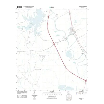
2012 Map of Lecompte
USGS Topo · Published 2012About this map
Lecompte sits as a primary settlement in Rapides Parish, defined by the winding course of Bayou Boeuf and a network of agricultural and timber lands. This 2012 survey illustrates the region’s complex water system, ranging from the large Indian Creek Reservoir and the Beechfish Fish Hatchery in the west to the wetlands of Mathews Brake and Cocodrie Lake in the south. The landscape is dotted with numerous family and community burial grounds, such as Wilmer Memorial Cem, Ballard Cem, and Linzay Cem, which provide significant genealogical data for researchers of the area. Small communities like Midway and Meeker are connected by local routes like Joe Gunter Rd and Wiggins Rd, showing how the rural road network has evolved to serve these dispersed settlements between the bayou and the piney woods.
Find a feature on this map
84 named features on this map. Tap any name to fly to it.
Don’t see what you’re looking for? This feature index may not catch every label — zoom into the map to look around manually.
Map Details
Editions of this 2012 Lecompte Map
This is the sole edition of this map. No revisions or reprints were ever made.
Other maps of this area

1935 · Turkey Creek
USGS Topo · 1:62,500

1935 · Lecompte
USGS Topo · 1:62,500

1942 · Oakdale
USGS Topo · 1:62,500

1949 · Glenmora
USGS Topo · 1:31,680

1949 · Turkey Creek
USGS Topo · 1:62,500

1952 · Lake Charles
USGS Topo · 1:250,000

1953 · Alexandria
USGS Topo · 1:250,000

1954 · Lake Charles
USGS Topo · 1:250,000

1955 · Alexandria
USGS Topo · 1:250,000

1956 · Forest Hill
USGS Topo · 1:62,500