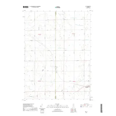
2018 Map of Lee
USGS Topo · Published 2018About this map
Lee and Shabbona anchor this agricultural landscape along the shared border of Lee and DeKalb counties. The terrain is defined by the headwaters of the Kishwaukee River system, including the S Br Kishwaukee River and its various tributaries like the Middle Br S Br Kishwaukee River. These waterways, along with Steward Cr and Dry Run, dictate the placement of early farmsteads and rural roads that follow the rigid section lines of the Public Land Survey System.
Find a feature on this map
50 named features on this map. Tap any name to fly to it.
Don’t see what you’re looking for? This feature index may not catch every label — zoom into the map to look around manually.
Map Details
Editions of this 2018 Lee Map
This is the sole edition of this map. No revisions or reprints were ever made.
Other maps of this area

1934 · De Kalb
USGS Topo · 1:62,500

1937 · De Kalb
USGS Topo · 1:62,500

1951 · Earlville
USGS Topo · 1:62,500

1952 · Rochelle
USGS Topo · 1:62,500

1952 · Mendota
USGS Topo · 1:62,500

1958 · Aurora
USGS Topo · 1:250,000

1961 · Aurora
USGS Topo · 1:250,000
1971 · Lee
USGS Topo · 1:24,000
1971 · Paw Paw
USGS Topo · 1:24,000
1971 · Waterman
USGS Topo · 1:24,000