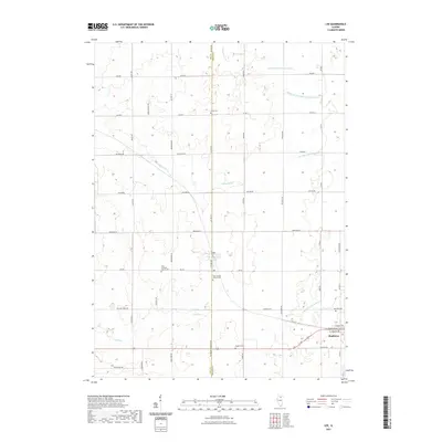
2021 Map of Lee
USGS Topo · Published 2021About this map
Lee and Shabbona anchor this agricultural landscape along the boundary of Lee and DeKalb counties. The terrain is defined by the headwaters of the Kishwaukee River system, including the N Br S Br Kishwaukee River and the Middle Br S Br Kishwaukee River. These waterways, along with Steward Cr and Dry Run, weave through a grid of rural roads that have serviced local farmsteads for generations. A high density of pioneer and denominational burial sites, such as the First Lutheran Church Cem and Saint James Calvary Cem, provides a detailed record of the families that settled this prairie. In Shabbona, a distinct residential street plan is visible with local thoroughfares like W Navaho Ave and W Comanche Ave. The map also captures the essential infrastructure of these small communities, including the Po in Lee.
Find a feature on this map
45 named features on this map. Tap any name to fly to it.
Don’t see what you’re looking for? This feature index may not catch every label — zoom into the map to look around manually.
Map Details
Editions of this 2021 Lee Map
This is the sole edition of this map. No revisions or reprints were ever made.
Other maps of this area

1934 · De Kalb
USGS Topo · 1:62,500

1937 · De Kalb
USGS Topo · 1:62,500

1951 · Earlville
USGS Topo · 1:62,500

1952 · Rochelle
USGS Topo · 1:62,500

1952 · Mendota
USGS Topo · 1:62,500

1958 · Aurora
USGS Topo · 1:250,000

1961 · Aurora
USGS Topo · 1:250,000
1971 · Lee
USGS Topo · 1:24,000
1971 · Paw Paw
USGS Topo · 1:24,000
1971 · Waterman
USGS Topo · 1:24,000