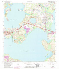
1965 Map of Leesburg East
USGS Topo · Published 1989About this map
Leesburg and its surrounding lakefront communities occupy a distinctive aquatic landscape defined by the connections between Lake Griffin, Lake Harris, and Lake Eustis. In the mid-1960s, the area's geography was still heavily influenced by the citrus industry and the Seaboard Coast Line railroad, which provided the primary transport corridors through settlements like Sunnyside and Orange Bend. The presence of several sandpits and claypits near Tomato Hill points to the local extraction economy alongside the developing residential centers of Bassville Park and Lisbon.
Find a feature on this map
51 named features on this map. Tap any name to fly to it.
Don’t see what you’re looking for? This feature index may not catch every label — zoom into the map to look around manually.
Map Details
Editions of this 1965 Leesburg East Map
3 editions found
Other maps of this area

1955 · Orlando
USGS Topo · 1:250,000

1957 · Orlando
USGS Topo · 1:250,000

1958 · Orlando
USGS Topo · 1:250,000

1962 · Orlando
USGS Topo · 1:250,000

1962 · Astatula
USGS Topo · 1:24,000

1965 · Leesburg East
USGS Topo · 1:24,000

1965 · Umatilla
USGS Topo · 1:24,000

1966 · Leesburg West
USGS Topo · 1:24,000
1966 · Lady Lake
USGS Topo · 1:24,000
1966 · Eustis
USGS Topo · 1:24,000