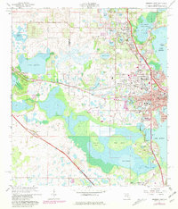
1966 Map of Leesburg West
USGS Topo · Published 1981About this map
The central Florida wetlands and citrus-belt settlements of Leesburg and Fruitland Park are intricately documented during a period of mid-century growth. This 1966 survey, with photorevisions in 1980, reveals a landscape defined by its complex hydrology, where Lake Harris, Lake Griffin, and Lake Denham are connected by waterways like the Dead River and Helena Run. The map provides significant detail for local researchers, capturing the transition from agricultural roots—indicated by numerous claypits and rail-dependent hamlets like Bamboo and Whitney—to modern infrastructure. Significant landmarks such as Johnson Jr College, the Flying Baron Airport, and the Drive-in Theater appear alongside long-standing community centers like Shiloh Cemetery and the Mt Olive Church. The intricate network of the Seaboard Coast Line railroad and the expansion of Florida's Turnpike illustrate the area's increasing connectivity between the coastal regions and the interior.
Find a feature on this map
64 named features on this map. Tap any name to fly to it.
Don’t see what you’re looking for? This feature index may not catch every label — zoom into the map to look around manually.
Map Details
Editions of this 1966 Leesburg West Map
5 editions found

Other maps of this area

1893 · Panasoffkee
USGS Topo · 1:62,500

1895 · Panasoffkee
USGS Topo · 1:62,500

1955 · Plant City
USGS Topo · 1:250,000

1955 · Orlando
USGS Topo · 1:250,000

1957 · Orlando
USGS Topo · 1:250,000

1958 · Orlando
USGS Topo · 1:250,000

1958 · Plant City
USGS Topo · 1:250,000

1958 · Bushnell
USGS Topo · 1:24,000

1959 · Plant City
USGS Topo · 1:250,000

1962 · Orlando
USGS Topo · 1:250,000