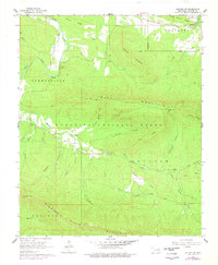
1966 Map of Leflore SE
USGS Topo · Published 1978About this map
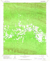
Ouachita National Forest dominates the landscape of this mid-1960s survey, showing a terrain defined by steep ridges and deep hollows. The valley of Holson Creek serves as a central artery for the small community surrounding the Holson Valley Ch and Holson Valley Cem, which are linked by Valley Road. Settled pockets like Reichert and the edges of Summerfield and Heavener appear along the northern and eastern borders, where the ground levels out near Coleman Ridge. The southern portion of the map is defined by the high elevations of Winding Stair Mountain and Blue Mountain, separated by the distinct passage of Deadman Gap. Numerous named drainages, including Wildhorse Creek and Lillard Creek, illustrate the complex watershed that feeds into the larger valley system during this era of forest management.
Find a feature on this map
36 named features on this map. Tap any name to fly to it.
Don’t see what you’re looking for? This feature index may not catch every label — zoom into the map to look around manually.
Map Details
Editions of this 1966 Leflore SE Map
2 editions found
Other maps of this area

1900 · Winding Stair
USGS Topo · 1:125,000

1909 · Winding Stair
USGS Topo · 1:125,000

1950 · Mcalester
USGS Topo · 1:250,000

1959 · Page
USGS Topo · 1:62,500

1959 · Heavener
USGS Topo · 1:62,500

1962 · McAlester
USGS Topo · 1:250,000

1965 · McAlester
USGS Topo · 1:250,000
1965 · Leflore
USGS Topo · 1:24,000
1965 · Summerfield
USGS Topo · 1:24,000
1966 · Muse
USGS Topo · 1:24,000