
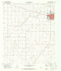
1969 Map of Lehman
USGS Topo · Published 1973About this map
The Levelland and Slaughter Oil and Gas Field dominates the southern landscape of this Cochran County quadrangle, a region defined by its industrial infrastructure and West Texas energy production. Centered on the community of Lehman, the survey documents the critical intersection of transport and extraction as the Atchison Topeka and Santa Fe railroad line runs east-west across the northern section. The terrain is marked by numerous wells and drill holes, with specific industrial landmarks such as the Lehman Gasoline Plant and various Storage Bins supporting the local economy. Water management and drainage are visible through the winding course of Sulphur Draw, which cuts through the oil fields. This 1969 data provides a clear record of the post-war petroleum boom's footprint, including utility features like a Radio Tower and public rest spots like the Roadside Park.
Find a feature on this map
9 named features on this map. Tap any name to fly to it.
Don’t see what you’re looking for? This feature index may not catch every label — zoom into the map to look around manually.
Map Details
Editions of this 1969 Lehman Map
This is the sole edition of this map. No revisions or reprints were ever made.
Other maps of this area

1954 · Brownfield
USGS Topo · 1:250,000

1958 · Brownfield
USGS Topo · 1:250,000

1962 · Brownfield
USGS Topo · 1:250,000

1970 · Morton SW
USGS Topo · 1:24,000

1970 · Whiteface SW
USGS Topo · 1:24,000

1970 · Morton NW
USGS Topo · 1:24,000

1970 · Plains 1 NW
USGS Topo · 1:24,000

1971 · Whiteface NW
USGS Topo · 1:24,000

1971 · Schooler Ranch
USGS Topo · 1:24,000
1971 · Morton
USGS Topo · 1:24,000