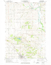
1971 Map of Lena
USGS Topo · Published 1974About this map
Lena and Winslow anchor this Northwest Illinois landscape during the early 1970s, a region defined by the winding course of the Pecatonica River and the expansive Lake Le-Aqua-Na State Park. The map captures a transition in rail history, showing the Illinois Central Gulf corridor passing through the heart of Lena while an Old RR Grade traces the former path of the Chicago, Milwaukee, St. Paul and Pacific through Winslow. This rural Stephenson County terrain is dotted with several small burial grounds, including Christian Hollow Cem and Crossroads Cem, which serve as vital markers for local genealogists. Extensive quarrying activity is evident across the townships of Winslow, West Point, and Waddams, reflecting the area's geological utility. Near the southern border, the Lena Flying Club Landing Field highlights local aviation interests of the era.
Find a feature on this map
50 named features on this map. Tap any name to fly to it.
Don’t see what you’re looking for? This feature index may not catch every label — zoom into the map to look around manually.
Map Details
Editions of this 1971 Lena Map
2 editions found
Other maps of this area

1920 · Monroe
USGS Topo · 1:62,500

1922 · Monroe
USGS Topo · 1:62,500

1923 · South Wayne
USGS Topo · 1:62,500

1937 · Lena
USGS Topo · 1:48,000

1939 · Freeport
USGS Topo · 1:48,000

1942 · Lena
USGS Topo · 1:62,500

1943 · Lena
USGS Topo · 1:62,500

1944 · Freeport
USGS Topo · 1:62,500

1954 · Rockford
USGS Topo · 1:250,000

1955 · Rockford
USGS Topo · 1:250,000