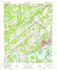
1968 Map of Lenoir City
USGS Topo · Published 1977About this map
Lenoir City serves as a focal point along the Tennessee River, illustrating a landscape in transition as the Tennessee Valley Authority reshapes the region's waterways. This 1968 revision captures the early construction phases of the Tellico Dam at the confluence of the Little Tennessee River and the Tennessee, a project that would fundamentally alter the hydrology of Hall Bend and Blair Bend. Beyond the industrial activity of the city and its Southern Railway connections, the map preserves rural landmarks like Pawpaw Plains and Eaton Crossroads.
Find a feature on this map
74 named features on this map. Tap any name to fly to it.
Don’t see what you’re looking for? This feature index may not catch every label — zoom into the map to look around manually.
Map Details
Editions of this 1968 Lenoir City Map
4 editions found
Other maps of this area

1895 · Loudon
USGS Topo · 1:125,000

1935 · Meadow
USGS Topo · 1:24,000

1935 · Lenoir City
USGS Topo · 1:24,000

1935 · Elverton
USGS Topo · 1:24,000

1935 · Bethel Valley
USGS Topo · 1:24,000

1935 · Philadelphia
USGS Topo · 1:24,000

1935 · Lovell
USGS Topo · 1:24,000

1936 · Cave Creek
USGS Topo · 1:24,000

1936 · Friendship
USGS Topo · 1:48,000

1936 · Loudon
USGS Topo · 1:24,000