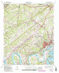
1968 Map of Lenoir City
USGS Topo · Published 1987About this map
Lenoir City serves as the focal point of this Tennessee Valley landscape, positioned where the Tennessee River meets the Little Tennessee River. This 1968 revision, with photorevisions from 1981, documents the significant hydrographic changes brought by the Tellico Dam, showing the formation of Tellico Lake and its effect on the shoreline near Bussell Island. The map records a complex transport network of the Southern railroad and major road projects like Kingston Pike. Rural life persists in the surrounding ridges and valleys, captured through numerous local landmarks such as Vaught Chapel, Browder Sch, and the Lenoir City Lookout Tower. Genealogists will find many family burial grounds documented, including Cardwell Cem, Abbott Cem, and Eldridge Cem. The ridge-and-valley topography of Blackoak Ridge and Hines Valley dictates the settlement patterns from Pawpaw Plains to Eaton Forest.
Find a feature on this map
58 named features on this map. Tap any name to fly to it.
Don’t see what you’re looking for? This feature index may not catch every label — zoom into the map to look around manually.
Map Details
Editions of this 1968 Lenoir City Map
4 editions found
Other maps of this area

1895 · Loudon
USGS Topo · 1:125,000

1935 · Meadow
USGS Topo · 1:24,000

1935 · Lenoir City
USGS Topo · 1:24,000

1935 · Elverton
USGS Topo · 1:24,000

1935 · Bethel Valley
USGS Topo · 1:24,000

1935 · Philadelphia
USGS Topo · 1:24,000

1935 · Lovell
USGS Topo · 1:24,000

1936 · Cave Creek
USGS Topo · 1:24,000

1936 · Friendship
USGS Topo · 1:48,000

1936 · Loudon
USGS Topo · 1:24,000