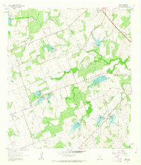
1961 Map of Lenz
USGS Topo · Published 1963About this map
Lenz sits as a quiet rural hub in Karnes County, surrounded by a complex network of ranching land and seasonal waterways. Surveyed in the early 1960s, the landscape is defined by the drainage of Escondido Creek and Olmos Creek, where numerous small dams and spillways indicate an era of active water management and soil conservation. The infrastructure of the period is visible through the Pipeline corridors cutting across the terrain and the presence of several Quarry sites.
Find a feature on this map
12 named features on this map. Tap any name to fly to it.
Don’t see what you’re looking for? This feature index may not catch every label — zoom into the map to look around manually.
Map Details
Editions of this 1961 Lenz Map
2 editions found
Other maps of this area

1925 · Tordia No. 1
USGS Topo · 1:48,000

1931 · Falls City
USGS Topo · 1:62,500

1936 · Pettus
USGS Topo · 1:62,500

1953 · Crystal City
USGS Topo · 1:250,000

1953 · Beeville
USGS Topo · 1:250,000

1955 · Crystal City
USGS Topo · 1:250,000

1956 · Suniland
USGS Topo · 1:62,500

1956 · Beeville
USGS Topo · 1:250,000

1956 · Pettus
USGS Topo · 1:62,500

1956 · Karnes City
USGS Topo · 1:62,500