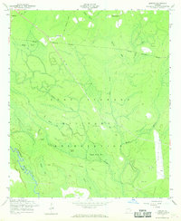
1958 Map of Letford
USGS Topo · Published 1969About this map
Fort Stewart Military Reservation dominates this Georgia landscape, its boundary cutting through a complex network of bays and wetlands. The terrain is defined by low-lying basins like Boggy Head Bay, Jones Bay, and Alligator Bay, which drain toward the Canoochee River in the southwest. For local historians, the sheet identifies significant vanished landmarks, most notably the Letford (Site) and an Old Railroad Grade that speaks to the area's earlier industrial or transit patterns before the expansion of the military facility. Scattered evidence of earlier community life remains in the form of Beulah Ch, Little Creek Cem, and Corinth Cem. The presence of Hilliard Island amidst the boggy terrain illustrates the intricate hydrology of the Bryan and Liberty County border region during the late 1950s.
Find a feature on this map
23 named features on this map. Tap any name to fly to it.
Don’t see what you’re looking for? This feature index may not catch every label — zoom into the map to look around manually.
Map Details
Editions of this 1958 Letford Map
3 editions found
Other maps of this area

1918 · Hinesville
USGS Topo · 1:62,500

1920 · Pembroke
USGS Topo · 1:62,500

1920 · Meldrim
USGS Topo · 1:62,500

1920 · Limerick
USGS Topo · 1:62,500

1942 · Meldrim
USGS Topo · 1:62,500

1944 · Hinesville
USGS Topo · 1:62,500

1944 · Limerick
USGS Topo · 1:62,500

1946 · Brunswick
USGS Topo · 1:250,000

1947 · Savannah
USGS Topo · 1:250,000

1948 · Brunswick
USGS Topo · 1:250,000