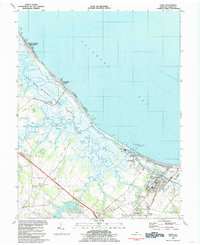
1984 Map of Lewes
USGS Topo · Published 1985About this map
Prime Hook National Wildlife Refuge and the expansive Great Marsh dominate the coastal landscape of Sussex County in the mid-1980s. This survey details the intricate network of waterways including Primehook Creek and the Broadkill River, which wind through wetlands punctuated by historical landings such as Robertson Landing and Hazzard Landing. The map captures the coastal transition from the preserved marshes to the developing town of Lewes, where the Univ of Delaware Col of Marine Studies sits near Breakwater Harbor.
Find a feature on this map
62 named features on this map. Tap any name to fly to it.
Don’t see what you’re looking for? This feature index may not catch every label — zoom into the map to look around manually.
Map Details
Editions of this 1984 Lewes Map
Other maps of this area

1917 · Millsboro
USGS Topo · 1:62,500

1918 · Cedar Creek
USGS Topo · 1:62,500

1918 · Rehoboth
USGS Topo · 1:62,500

1918 · Cape Henlopen
USGS Topo · 1:62,500

1919 · Cedar Creek
USGS Topo · 1:62,500

1937 · Cape Henlopen
USGS Topo · 1:62,500

1938 · Cedar Creek
USGS Topo · 1:62,500

1938 · Millsboro
USGS Topo · 1:62,500

1938 · Rehoboth
USGS Topo · 1:62,500

1943 · Fairmount
USGS Topo · 1:24,000