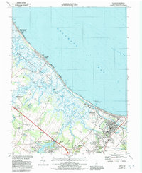
1984 Map of Lewes
USGS Topo · Published 1992About this map
The coastal interface of Delaware Bay and Sussex County is defined here by a vast network of salt marshes, reaches, and established maritime settlements. The town of Lewes serves as the focal point, showing a complex infrastructure of the late 20th century including the Univ of Delaware Col of Marine Studies, Cape Henlopen High Sch, and the Coast Guard Sta guarding Breakwater Harbor. The landscape is a study in preservation and water management, with the Prime Hook National Wildlife Refuge and Cape Henlopen State Park anchoring the coastline.
Find a feature on this map
81 named features on this map. Tap any name to fly to it.
Don’t see what you’re looking for? This feature index may not catch every label — zoom into the map to look around manually.
Map Details
Editions of this 1984 Lewes Map
Other maps of this area

1917 · Millsboro
USGS Topo · 1:62,500

1918 · Cedar Creek
USGS Topo · 1:62,500

1918 · Rehoboth
USGS Topo · 1:62,500

1918 · Cape Henlopen
USGS Topo · 1:62,500

1919 · Cedar Creek
USGS Topo · 1:62,500

1937 · Cape Henlopen
USGS Topo · 1:62,500

1938 · Cedar Creek
USGS Topo · 1:62,500

1938 · Millsboro
USGS Topo · 1:62,500

1938 · Rehoboth
USGS Topo · 1:62,500

1943 · Fairmount
USGS Topo · 1:24,000