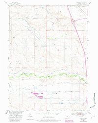
1953 Map of Lewis Flat
USGS Topo · Published 1982About this map
North Laramie River carves a fertile path through this portion of Platte County, supporting an extensive network of irrigation infrastructure critical to high-plains agriculture. The landscape of Lewis Flat is defined by its ranching heritage, with family-named operations such as the Old Mitchell Home Ranch, G Mitchell Ranch, and Patterson Ranch established near the water's edge. This map reveals a complex system of water management, ranging from the active North Laramie Canal and Mitchell Ditch to the defunct Lowrica Ditch No 2 (Abandoned). The presence of the Lewis School and several windmills suggests a dispersed but structured rural community during the mid-20th century. Further south, Reservoir No 1 and Reservoir No 2 collect the scarce water resources of the region, while natural features like Mud Springs and Fish Creek provide the fundamental drainage for the surrounding terrain.
Find a feature on this map
27 named features on this map. Tap any name to fly to it.
Don’t see what you’re looking for? This feature index may not catch every label — zoom into the map to look around manually.
Map Details
Editions of this 1953 Lewis Flat Map
2 editions found

Other maps of this area

1896 · Hartville
USGS Topo · 1:125,000

1901 · Hartville
USGS Topo · 1:125,000

1950 · Coleman Butte
USGS Topo · 1:24,000

1950 · Herman Ranch
USGS Topo · 1:24,000

1950 · Cottonwood Falls
USGS Topo · 1:24,000

1951 · Coleman Butte
USGS Topo · 1:24,000

1951 · Cottonwood Falls
USGS Topo · 1:24,000
1951 · Herman Ranch
USGS Topo · 1:24,000

1951 · Dwyer
USGS Topo · 1:24,000
1951 · Wheatland
USGS Topo · 1:24,000