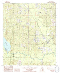
1985 Map of Lillie
USGS Topo · Published 1986About this map
Lillie serves as the primary hub in this northern Louisiana landscape, situated amidst a dense network of tributaries that feed into the Little Corney Bayou and Corney Bayou. The terrain is characterized by its agricultural and forest management patterns, with significant acreage dedicated to the Kisatchie National Forest on the western edge of the quadrangle. Smaller rural settlements like Randolph and Rum Center are documented alongside local community pillars such as Bethel church and several small Cem locations, which provide essential touchpoints for genealogical research in Union Parish.
Find a feature on this map
28 named features on this map. Tap any name to fly to it.
Don’t see what you’re looking for? This feature index may not catch every label — zoom into the map to look around manually.
Map Details
Editions of this 1985 Lillie Map
This is the sole edition of this map. No revisions or reprints were ever made.
Other maps of this area

1927 · El Dorado
USGS Topo · 1:62,500

1930 · El Dorado
USGS Topo · 1:62,500

1951 · Summerfield
USGS Topo · 1:62,500

1951 · Bernice
USGS Topo · 1:62,500

1951 · El Dorado
USGS Topo · 1:62,500

1953 · El Dorado
USGS Topo · 1:250,000

1955 · Shreveport
USGS Topo · 1:250,000

1956 · Shreveport
USGS Topo · 1:250,000

1957 · El Dorado
USGS Topo · 1:250,000

1958 · El Dorado
USGS Topo · 1:250,000