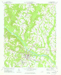
1978 Map of Lillington
USGS Topo · Published 1978About this map
The Cape Fear River bisects this late-1970s landscape, serving as the central geographic feature for the Harnett County seat. In Lillington, the presence of the Filtration Plant, Sewage Disposal Ponds, and a dedicated Boat Ramp underscores the town's mid-century utility and its relationship with the water. The Norfolk Southern railroad runs north-south through the county, passing through the community of Kipling and linking the riverside commerce of Lillington to the surrounding rural districts. To the south, Shawtown sits near Wesley Chapel, representing the small-scale residential clusters that characterize the area outside the primary town center.
Find a feature on this map
55 named features on this map. Tap any name to fly to it.
Don’t see what you’re looking for? This feature index may not catch every label — zoom into the map to look around manually.
Map Details
Editions of this 1978 Lillington Map
2 editions found
Other maps of this area

1953 · Raleigh
USGS Topo · 1:250,000

1954 · Raleigh
USGS Topo · 1:250,000

1956 · Anderson Creek
USGS Topo · 1:24,000

1956 · Bunnlevel
USGS Topo · 1:24,000

1964 · Angier
USGS Topo · 1:24,000

1964 · Garner
USGS Topo · 1:62,500

1973 · Erwin
USGS Topo · 1:24,000

1973 · Coats
USGS Topo · 1:24,000
1974 · Fuquay-Varina
USGS Topo · 1:24,000

1974 · Mamers
USGS Topo · 1:24,000