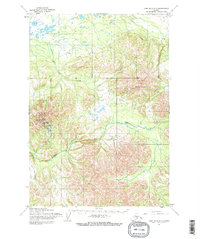
1954 Map of Lime Hills A-7
USGS Topo · Published 1968About this map
Sparrevohn Air Force Station anchors the west side of this mid-century survey, reflecting Cold War-era defense priorities in the Alaskan interior. This installation is paired with a nearby Landing Strip, providing a rare point of human infrastructure in an otherwise remote landscape defined by complex hydrology. The drainage of Hook Creek and Caribou Snare Creek dominates the valley floors between significant peaks, including Cairn Mountain to the northeast. Mapped during the mid-1950s using photogrammetric methods from aerial photography, the sheet records the topography of the Lime Hills before significant modern shifts, capturing the precise layout of the early Air Force station and its relation to the surrounding unsurveyed land lines.
Find a feature on this map
5 named features on this map. Tap any name to fly to it.
Don’t see what you’re looking for? This feature index may not catch every label — zoom into the map to look around manually.
Map Details
Editions of this 1954 Lime Hills A-7 Map
2 editions found
Other maps of this area

1946 · Lake Clark
USGS Topo · 1:250,000

1951 · Lake Clark
USGS Topo · 1:250,000

1951 · Lime Hills
USGS Topo · 1:250,000

1954 · Lime Hills A-8
USGS Topo · 1:63,360

1954 · Lake Clark D-8
USGS Topo · 1:63,360

1954 · Lake Clark D-7
USGS Topo · 1:63,360

1954 · Lime Hills B-7
USGS Topo · 1:63,360

1954 · Lime Hills A-7
USGS Topo · 1:63,360

1954 · Lime Hills A-6
USGS Topo · 1:63,360
1954 · Lake Clark D-6
USGS Topo · 1:63,360