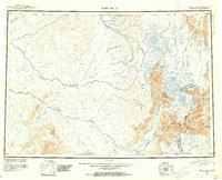
1951 Map of Lime Hills
USGS Topo · Published 1952About this map
The Alaska Range dominates the eastern landscape of this interior survey, where the glacial headwaters of several major river systems converge. Steep terrain gives way to the broad, braided valleys of the Stony River and the Swift River, which cut through the namesake Lime Hills. At this mid-century point, the area remained largely inaccessible by road, defined instead by mountain crossings like Merrill Pass and Sled Pass. These corridors provided critical passage through the high peaks for travelers moving between the South Fork Kuskokwim River drainage and the Cook Inlet watersheds. Scattered signs of human presence are limited to isolated outposts such as a Cabin near Two Lakes, reflecting the extreme isolation of the region before modern infrastructure. The map captures the complex hydrology of the western mountain front, including the winding courses of the Big River and Hartman River.
Find a feature on this map
31 named features on this map. Tap any name to fly to it.
Don’t see what you’re looking for? This feature index may not catch every label — zoom into the map to look around manually.
Map Details
Editions of this 1951 Lime Hills Map
4 editions found

Other maps of this area

1944 · Kenai
USGS Topo · 1:250,000

1946 · Lake Clark
USGS Topo · 1:250,000

1949 · Tyonek
USGS Topo · 1:250,000

1949 · McGrath
USGS Topo · 1:250,000

1950 · Kenai
USGS Topo · 1:250,000

1950 · Sleetmute
USGS Topo · 1:250,000

1950 · McGrath
USGS Topo · 1:250,000

1950 · Talkeetna
USGS Topo · 1:250,000

1950 · Taylor Mountains
USGS Topo · 1:250,000

1951 · Talkeetna
USGS Topo · 1:250,000