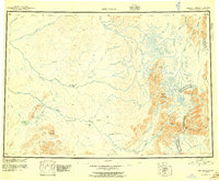
1951 Map of Lime Hills
USGS Topo · Published 1956About this map
Hungry Village and the high peaks of the Alaska Range define this mid-century portrait of a vast, roadless interior. The landscape is dominated by the massive drainage systems of the Stony River and the South Fork Kuskokwim River, which carve through the Lime Hills and surrounding lowlands. This survey documents a wilderness accessible primarily by water or air, showing only isolated cabins and traditional indigenous settlements near Salmon Berry Lake and the various forks of the Big River. Significant mountain landmarks like Snowcap Mountain and Cairn Mountain rise above the river valleys, while Merrill Pass and Sied Pass suggest the natural corridors used for travel across the divide. The map also delineates the administrative boundary between the Fourth and Third Judicial Divisions, providing a spatial record of Alaskan governance before statehood.
Find a feature on this map
49 named features on this map. Tap any name to fly to it.
Don’t see what you’re looking for? This feature index may not catch every label — zoom into the map to look around manually.
Map Details
Editions of this 1951 Lime Hills Map
4 editions found

Other maps of this area

1944 · Kenai
USGS Topo · 1:250,000

1946 · Lake Clark
USGS Topo · 1:250,000

1949 · Tyonek
USGS Topo · 1:250,000

1949 · McGrath
USGS Topo · 1:250,000

1950 · Kenai
USGS Topo · 1:250,000

1950 · Sleetmute
USGS Topo · 1:250,000

1950 · McGrath
USGS Topo · 1:250,000

1950 · Talkeetna
USGS Topo · 1:250,000

1950 · Taylor Mountains
USGS Topo · 1:250,000

1951 · Talkeetna
USGS Topo · 1:250,000