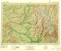
1951 Map of Lime Hills
USGS Topo · Published 1956About this map
The Stony River and Swift River systems dominate this interior Alaskan landscape, providing a complex network of waterways that defined travel and subsistence long before modern infrastructure. Central to the western half is Hungry Village (Native Village), a key point of habitation along Hungry Creek. The map documents a transition from the lower river valleys to the high peaks of the Lime Hills and the Aleutian Range, where glaciers feed into the Merrill River and Another River.
Find a feature on this map
47 named features on this map. Tap any name to fly to it.
Don’t see what you’re looking for? This feature index may not catch every label — zoom into the map to look around manually.
Map Details
Editions of this 1951 Lime Hills Map
4 editions found

Other maps of this area

1944 · Kenai
USGS Topo · 1:250,000

1946 · Lake Clark
USGS Topo · 1:250,000

1949 · Tyonek
USGS Topo · 1:250,000

1949 · McGrath
USGS Topo · 1:250,000

1950 · Kenai
USGS Topo · 1:250,000

1950 · Sleetmute
USGS Topo · 1:250,000

1950 · McGrath
USGS Topo · 1:250,000

1950 · Talkeetna
USGS Topo · 1:250,000

1950 · Taylor Mountains
USGS Topo · 1:250,000

1951 · Talkeetna
USGS Topo · 1:250,000