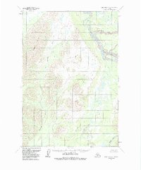
1954 Map of Lime Hills D-5
USGS Topo · Published 1988About this map
Gagaryah River snakes through a landscape defined by dramatic elevation changes, flowing from the foothills of the Lyman Hills toward the broad valley of the Big River. This mid-century survey captures the interior wilderness of the Bethel region before significant modern alteration, highlighting a complex network of glacial and alluvial water systems. In the northeastern portion of the quadrangle, the North Fork of the Big River creates a wide, braided floodplain, while the southern reaches are marked by the headwaters of the Babel River. The landform distribution shown here reflects the transitional topography between high alpine ridges and the low-lying wetlands of the Alaskan interior, providing an essential record for those studying the natural drainage patterns and unroaded geography of the era.
Find a feature on this map
5 named features on this map. Tap any name to fly to it.
Don’t see what you’re looking for? This feature index may not catch every label — zoom into the map to look around manually.
Map Details
Editions of this 1954 Lime Hills D-5 Map
3 editions found
Other maps of this area

1949 · McGrath
USGS Topo · 1:250,000

1950 · McGrath
USGS Topo · 1:250,000

1951 · Lime Hills
USGS Topo · 1:250,000

1954 · McGrath A-4
USGS Topo · 1:63,360

1954 · Lime Hills D-6
USGS Topo · 1:63,360

1954 · Lime Hills D-5
USGS Topo · 1:63,360

1954 · Lime Hills C-6
USGS Topo · 1:63,360
1954 · Lime Hills C-5
USGS Topo · 1:63,360

1958 · McGrath A-3
USGS Topo · 1:63,360

1958 · Lime Hills C-4
USGS Topo · 1:63,360