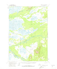
1954 Map of Lime Hills D-8
USGS Topo · Published 1973About this map
Tatlawiksuk River meanders across the northern portion of this 1950s interior landscape, defining a region characterized by extensive wetlands and complex drainage patterns. The territory, as documented by the Geological Survey during this era, remains largely untouched by roads or permanent settlements. South of the Tatlawiksuk, the Cheeneetnuk River carves a winding path through the center of the sheet, while the Swift River cuts across the southwestern corner. The mapping reveals a landscape of transition, where low-lying swampy terrain meets isolated upland ridges. These watercourses served as the primary natural corridors for movement through the unsurveyed and unmarked lands of the Seward Meridian, long before any modern infrastructure altered the drainage of the Kuskokwim River basin area.
Find a feature on this map
3 named features on this map. Tap any name to fly to it.
Don’t see what you’re looking for? This feature index may not catch every label — zoom into the map to look around manually.
Map Details
Editions of this 1954 Lime Hills D-8 Map
2 editions found
Other maps of this area

1949 · McGrath
USGS Topo · 1:250,000

1950 · Sleetmute
USGS Topo · 1:250,000

1950 · McGrath
USGS Topo · 1:250,000

1951 · Lime Hills
USGS Topo · 1:250,000

1951 · Iditarod
USGS Topo · 1:250,000

1954 · Sleetmute D-1
USGS Topo · 1:63,360

1954 · Sleetmute C-1
USGS Topo · 1:63,360

1954 · Iditarod A-1
USGS Topo · 1:63,360
1954 · Lime Hills D-7
USGS Topo · 1:63,360
1954 · Lime Hills C-7
USGS Topo · 1:63,360