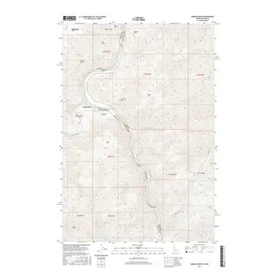
2017 Map of Limekiln Rapids
USGS Topo · Published 2017About this map
The Snake River carves a deep, winding path through this corner of the Pacific Northwest, marking the jurisdictional boundary between Idaho and Washington. At the confluence where the Grande Ronde River meets the Snake, the small settlement of Rogersburg serves as a remote outpost, supported by the Rogersburg Airport and Rogersburg Rd. The river's character is defined by a series of navigational challenges for boaters, including Captain Lewis Rapids, Limekiln Rapids, Negro Head Rapids, and Wild Goose Rapids. This 2017 survey reveals a landscape of stark elevation changes, from the heights of Gold Hill and Limestone Point down to the narrow river benches. Tributaries like Shovel Cr and China Garden Cr cut through the surrounding tablelands, illustrating the complex drainage system feeding into the main river channel.
Find a feature on this map
44 named features on this map. Tap any name to fly to it.
Don’t see what you’re looking for? This feature index may not catch every label — zoom into the map to look around manually.
Map Details
Editions of this 2017 Limekiln Rapids Map
This is the sole edition of this map. No revisions or reprints were ever made.
Other maps of this area

1944 · Anatone
USGS Topo · 1:62,500

1946 · Limekiln Rapids
USGS Topo · 1:62,500

1946 · Anatone
USGS Topo · 1:62,500

1955 · Pullman
USGS Topo · 1:250,000

1955 · Grangeville
USGS Topo · 1:250,000

1958 · Pullman
USGS Topo · 1:250,000

1959 · Grangeville
USGS Topo · 1:250,000

1963 · Jim Creek Butte
USGS Topo · 1:24,000

1963 · Wapshilla Creek
USGS Topo · 1:24,000
1967 · Teepee Butte
USGS Topo · 1:24,000