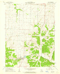
1961 Map of Lincoln
USGS Topo · Published 1962About this map
Lincoln serves as the central hub in this early 1960s survey of northern Benton County, where the settlement is surrounded by a network of rural landmarks and local waterways. The Chicago Rock Island and Pacific railroad cuts through the northern landscape, passing through Ionia and past Cole Camp Junction. The transition from the open fields of White township to the more varied terrain of Williams is marked by the winding courses of Cole Camp Creek and Williams Creek. This era of the Missouri landscape is defined by its deep-rooted community markers, including Zion Ch, Mt Olivet Ch, and Immanuel Ch, alongside several family and community burial grounds like Lincoln Cem. The presence of a Mine and Gravel Pit near the creek beds indicates the local extraction industry of the time, while Timber Line Lake provides a distinct water feature south of the primary town site.
Find a feature on this map
24 named features on this map. Tap any name to fly to it.
Don’t see what you’re looking for? This feature index may not catch every label — zoom into the map to look around manually.
Map Details
Editions of this 1961 Lincoln Map
2 editions found
Other maps of this area

1887 · Sedalia
USGS Topo · 1:125,000

1887 · Warsaw
USGS Topo · 1:125,000

1894 · Warsaw
USGS Topo · 1:125,000

1894 · Sedalia
USGS Topo · 1:125,000

1936 · Shawnee Bend
USGS Topo · 1:24,000

1936 · Lakeview Heights
USGS Topo · 1:24,000

1936 · Schuyler
USGS Topo · 1:24,000

1947 · Jefferson City
USGS Topo · 1:250,000
1948 · Green Ridge
USGS Topo · 1:62,500

1954 · Jefferson City
USGS Topo · 1:250,000