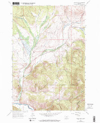
1962 Map of Lincoln Gulch
USGS Topo · Published 1974About this map
Deerlodge National Forest and Beaverhead National Forest converge in this high-elevation Montana landscape, marked by a dense network of gulches and creeks feeding the Big Hole River. The map captures a moment when traditional livestock ranching and recreational expansion existed side-by-side, evidenced by the numerous family-held properties like Ralston Ranch, Johnson Ranch, and Furguson Ranch situated near the Deep Creek Ski Area. The topography is dominated by dramatic drainage systems including French Gulch, Lincoln Gulch, and Tenmile Creek, which flow through steep terrain defined by Bear Mountain. This survey provides essential detail for researchers tracing the historical boundaries between Deer Lodge, Beaverhead, and Silver Bow counties in the early 1960s.
Find a feature on this map
38 named features on this map. Tap any name to fly to it.
Don’t see what you’re looking for? This feature index may not catch every label — zoom into the map to look around manually.
Map Details
Editions of this 1962 Lincoln Gulch Map
3 editions found

Other maps of this area

1889 · Helena
USGS Topo · 1:250,000

1893 · Helena
USGS Topo · 1:250,000

1893 · Dillon
USGS Topo · 1:250,000

1899 · Helena
USGS Topo · 1:250,000

1903 · Helena
USGS Topo · 1:250,000

1908 · Philipsburg
USGS Topo · 1:125,000

1947 · Butte
USGS Topo · 1:250,000

1955 · Dillon
USGS Topo · 1:250,000

1957 · Dillon
USGS Topo · 1:250,000

1958 · Butte
USGS Topo · 1:250,000