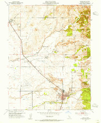
1953 Map of Lincoln
USGS Topo · Published 1955About this map
The Southern Pacific railroad corridor serves as the industrial spine for this Placer County landscape, connecting the agricultural and mining interests of Lincoln and Sheridan. The terrain is characterized by a series of parallel watercourses including Coon Creek, Doty Ravine, and Auburn Ravine, which are interspersed with evidence of significant land modification. Large areas of Dredge Tailings and an active Clay Pit reflect the region's extractive history, while the presence of the Lincoln Airport and a growing street grid in the town of Lincoln indicate mid-century modernization. Local history is anchored by landmarks such as Manzanita Cem, several windmills, and small rail-side settlements like Brock and Clayton. This survey offers a precise look at the transition from resource extraction to a more established residential and aviation-focused infrastructure.
Find a feature on this map
21 named features on this map. Tap any name to fly to it.
Don’t see what you’re looking for? This feature index may not catch every label — zoom into the map to look around manually.
Map Details
Editions of this 1953 Lincoln Map
4 editions found
Other maps of this area

1888 · Smartsville
USGS Topo · 1:125,000

1891 · Sacramento
USGS Topo · 1:125,000

1891 · Smartsville
USGS Topo · 1:125,000

1892 · Sacramento
USGS Topo · 1:125,000

1892 · Smartsville
USGS Topo · 1:125,000

1893 · Sacramento
USGS Topo · 1:125,000

1894 · Smartsville
USGS Topo · 1:125,000

1895 · Smartsville
USGS Topo · 1:125,000

1910 · Sheridan
USGS Topo · 1:31,680

1910 · Lincoln
USGS Topo · 1:31,680