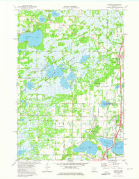
1974 Map of Lindstrom
USGS Topo · Published 1976About this map
The Carlos Avery State Wildlife Management Area dominates the central portion of this mid-1970s landscape, illustrating a vast protected wetland complex punctuated by numerous water bodies like Little Coon Lake and Boot Lake. To the north, the community of Linwood sits near the shores of Linwood Lake and Island Lake, with local history evidenced by the Linwood Sch and the Victor Hill Cem.
Find a feature on this map
44 named features on this map. Tap any name to fly to it.
Don’t see what you’re looking for? This feature index may not catch every label — zoom into the map to look around manually.
Map Details
Editions of this 1974 Lindstrom Map
2 editions found
Other maps of this area

1900 · St Croix Dalles
USGS Topo · 1:62,500

1901 · St Croix Dalles
USGS Topo · 1:62,500

1950 · Rush City
USGS Topo · 1:48,000

1951 · Milltown
USGS Topo · 1:48,000

1953 · Stillwater
USGS Topo · 1:250,000

1955 · St. Croix Dalles
USGS Topo · 1:62,500

1955 · Rush City
USGS Topo · 1:62,500

1955 · Milltown
USGS Topo · 1:62,500

1955 · Forest Lake
USGS Topo · 1:62,500

1955 · Stillwater
USGS Topo · 1:250,000