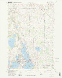
1974 Map of Lindstrom
USGS Topo · Published 1976About this map
Chisago Lake dominates the central landscape of this Minnesota survey, surrounding the town of Lindstrom and the nearby Center City with a complex network of glacial basins and peninsulas. The mid-1970s settlement pattern shows a concentration of activity along the islands and points, including Sunset Point and the residential areas flanking North Center Lake. To the north, the Sunrise River meanders through the township of Sunrise, while the presence of Kost Dam County Park near Kost reflects the regional reliance on these waterways for both utility and recreation.
Find a feature on this map
35 named features on this map. Tap any name to fly to it.
Don’t see what you’re looking for? This feature index may not catch every label — zoom into the map to look around manually.
Map Details
Editions of this 1974 Lindstrom Map
2 editions found
Other maps of this area

1900 · St Croix Dalles
USGS Topo · 1:62,500

1901 · St Croix Dalles
USGS Topo · 1:62,500

1950 · Rush City
USGS Topo · 1:48,000

1951 · Milltown
USGS Topo · 1:48,000

1953 · Stillwater
USGS Topo · 1:250,000

1955 · St. Croix Dalles
USGS Topo · 1:62,500

1955 · Rush City
USGS Topo · 1:62,500

1955 · Milltown
USGS Topo · 1:62,500

1955 · Forest Lake
USGS Topo · 1:62,500

1955 · Stillwater
USGS Topo · 1:250,000