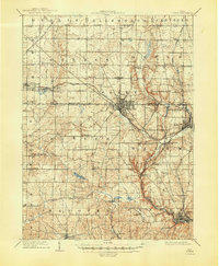
1909 Map of Lisbon
USGS Topo · Published 1948About this map
Lisbon and Salem anchor this early twentieth-century survey of northeastern Ohio, revealing a landscape defined by the intersection of industrial rail corridors and traditional agricultural townships. The Pennsylvania System and the Erie Railroad cut through the terrain, connecting centers like Leetonia and Washingtonville. These rail lines supported a growing manufacturing economy, while just beyond the tracks, the countryside remained dotted with local landmarks of nineteenth-century life, such as St Jacobs Church and the Penn School.
Find a feature on this map
71 named features on this map. Tap any name to fly to it.
Don’t see what you’re looking for? This feature index may not catch every label — zoom into the map to look around manually.
Map Details
Editions of this 1909 Lisbon Map
2 editions found
Other maps of this area

1904 · Wellsville
USGS Topo · 1:62,500

1905 · Salineville
USGS Topo · 1:62,500

1906 · Youngstown
USGS Topo · 1:62,500

1906 · Ravenna
USGS Topo · 1:62,500

1907 · Columbiana
USGS Topo · 1:62,500

1908 · Youngstown
USGS Topo · 1:62,500

1908 · Warren
USGS Topo · 1:62,500

1908 · Ravenna
USGS Topo · 1:62,500

1909 · Alliance
USGS Topo · 1:62,500

1909 · Lisbon
USGS Topo · 1:62,500