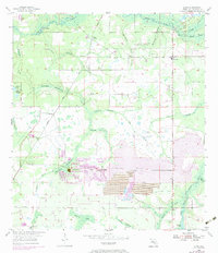
1955 Map of Lithia
USGS Topo · Published 1983About this map
The Alafia River winds through this Central Florida landscape, defined by its transition from agricultural hamlets to industrial extraction. Early 20th-century settlements like Lithia (Station), Boyette, and Pinecrest are situated alongside the Seaboard Coast Line railroad, which served the region's burgeoning phosphate interests. While northern sections of the map feature recreational and natural sites such as Lithia Springs and a Girl Scout Camp, the southern half is increasingly dominated by heavy industry. Large-scale Strip Mine operations and associated Tailings Ponds have reshaped the terrain around Stallion Hammock Branch and Flat Creek. These industrial features, many added during a 1972 revision, illustrate the shifting land use in Hillsborough County as traditional hammocks like Cabbage Hammock gave way to resource extraction and managed landscapes near the South Prong Alafia River.
Find a feature on this map
35 named features on this map. Tap any name to fly to it.
Don’t see what you’re looking for? This feature index may not catch every label — zoom into the map to look around manually.
Map Details
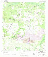
Editions of this 1955 Lithia Map
4 editions found
Other maps of this area

1921 · Tampa
USGS Topo · 1:62,500

1944 · Mango
USGS Topo · 1:31,680

1944 · Wimauma
USGS Topo · 1:31,680

1944 · Balm
USGS Topo · 1:31,680

1947 · Wimauma
USGS Topo · 1:25,000

1955 · Lithia
USGS Topo · 1:24,000

1955 · Nichols
USGS Topo · 1:24,000

1955 · Dover
USGS Topo · 1:24,000

1955 · Keysville
USGS Topo · 1:24,000
1956 · Riverview
USGS Topo · 1:24,000